
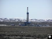
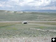
Natural Gas Drill Rig
The drill rig is onsite for only a few weeks, then is removed leaving several low to the ground structures with much less visual impact. This rig is located south of Pinedale on the cut-off road to Big Piney.
|
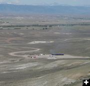
Drill Rig Gone
View of well pad once the drill rig is removed. Smoke is from burn-off of well fumes. This view is looking from the Mesa east at the Wind River Mountains, with Temple Peak visible. Pinedale is just to the left out of view. The ribbon of green vegetation is Pine Creek. Highway 191 runs left to right (which is north to south). The Pinedale airport is several miles out of picture to the right.
|
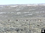
Antelope in Drilling Area
Many pronghorn antelope live and roam in the area where natural gas drilling is occuring. This picture was taken in June, 2003.
|
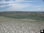
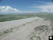
Drill Rig south of Pinedale
View looking northeast from the Mesa to a drill rig just south of Pinedale. Pinedale, the Wind River Mountains and Fremont Lake are visible in the background.
|
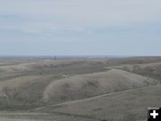
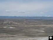
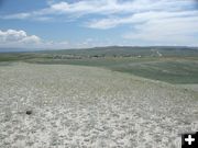
The Mesa south of Pinedale
Standing on the same spot as the photo above south of Pinedale, this photo is 180 degrees turned in the opposite direction looking further south deeper into the Mesa and natural gas development area near Pinedale. The area is high desert between the New Fork River out of sight to the left and the Green River out of sight to the right. Many miles in the distance is the site of the Jonah Field. This is the very northern end of that development area.
|
Trappers Point Underpass
View standing on Trappers Point looking north at Hwy 191 and the underpass used by ranchers to move cattle safely from one side of the highway to the other. Fences funnel animals to the underpass. This is what is called the Trappers Point bottleneck in the Upper Green. Pinedale is approximately 6 miles to the right. The Wind River Mountains are in the far distance. Photo taken July 25, 2004.
|
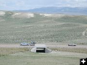
Close-up of Underpass
Close-up of the animal underpass on US Highway 191 at Trappers Point. View looking north into the Upper Green River area. This is BLM-managed land. Photo taken July 25, 2004.
|
Southern View Trappers Point
Another view of what is called the Trappers Point wildlife corridor bottleneck. View is looking to the south, standing on the north side of US Highway 191. Pinedale is approximately 6 miles to the left. The animal underpass is visible on the highway. Trappers Point monument is on the knoll just above the underpass and vehicles in view on the highway. Private land with residential development is on the left, BLM public land, and the Mesa to the south, encompasses most of the rest of the view. The Green River cuts a ribbon of green on the far right. Photo taken July 25, 2004.
|
Bottleneck north
Trappers Point wildlife corridor bottleneck as seen from the south looking north. View is perspective looking back at the one from the photo above. Residential homes on the right are just south of US Highway 191, which runs left to right. Pinedale is several miles to the right. Trappers Point monument is on the knoll to the left of this gravel road to the left of the homes. Picture taken July 25, 2004.
|
Trappers Point Homes
Subdivision at what is being called the Trappers Point bottleneck. This used to be called 'the Cora Y', Hwy 191 intersection. This is also the current site of the WYDOT Highway 191 web cam. Pinedale is several miles to the left. Highway 352, the road to Green River Lakes, takes off from Highway 191 here and goes to the left (north). Trappers Point monument is just out of picture to the right.
|
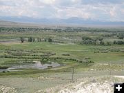
Rendezvous Grounds
Why is this location called Trappers Point? This knoll has a wonderful view of the historic Green River Rendezvous grounds of the early 1800s! This photo is looking from Trappers Point monument to the west at the Wyoming Range. The Green River meanders from right to left on its way to the Colorado River. Pinedale is behind the photographer about 6 miles. The confluence of Horse Creek and the Green River is just right of center along the 2nd left-right line of trees at the base of the hill. The hill just above centerline is the site of DeSmet Monument and the Daniel Cemetery. The water tower is visible between the two dirt roads that climb the hill. The tiny town of Daniel is in the trees to the right off of the hill. 168 years ago fur trappers and Native Americans camped here for weeks during the Green River Rendezvous.
|
|
Pinedale area featured on NightLine TV Program
Locals speak out on 'Range Wars'
by Dawn Ballou
July 25, 2004
On Thursday, July 22nd, ABC News featured the Pinedale area on the TV news program, Nightline, highlighting the oil and gas development vs. wildlife issue. The program, entitled 'Range Wars' with ABC interviewers Chris Bury and Judy Miller, focused on the difficult task the Bureau of Land Management has in Wyoming balancing managing one of the state's largest natural gas fields on public land near Pinedale with the livelihoods of the area's livestock producers and the political pressure of environmentalists who want minimal disturbance to native wildlife populations.
The program aired viewpoints from area environmental protectionists, ranchers, outfitters & guides, and natural gas industry representatives. Interviews were done during an environmentalist-group sponsored "Conservation Congress" held this past spring in Pinedale. Pinedale locals interviewed included Pinedale BLM Field Manager Prill Meacham, Cattle Rancher Tim Thompson, local outfitter & guide Courtney Skinner, Pinedale resident Ted Carasori, Questar Corporation representative Charles Stanley, local ranchers John and Shaun Andrikopoulos, and Upper Green River Valley Coalition environmentalist Linda Baker. Also interviewed were Wyoming Governor Dave Freudenthal and Secretary of the Interior Gale Norton.
Below are comments made during the program:
Linda Baker (Upper Green River Valley Coalition): "I'm not saying don't drill at all. I'm saying do it responsibly. Do it with some forethought. Make sure you have got baseline data."
Ted Carasori (Pinedale Resident): "Many of us feel that, given the enormous amounts of profits that are being generated here, $20 million from each well, that the Wyoming state government, and particularly the federal government, could mandate more wildlife-friendly gas development, in this area."
John Andrikopoulos (Rancher): "We're going too damn fast right now. We need to step back, take a look. We need to change the law. And we need to let the people that live on the land have a say in the planning of this."
Shaun Andrikopoulos (Rancher): "I want my kids to have the opportunity to grow up the way i did, out here, running cattle and really enjoying the open spaces and the solitude. And the reality of that is, on this particular ranch, that may not happen."
Tim Thompson (Cattle Rancher): "I might as well write my fly fishing deal off. 'Cause they're going to put roads in there. Where roads come, come people. Right now we park here and walk. There goes the aesthetic of it."
Courtney Skinner (Pinedale Resident and Outfitter & Guide): "It brings tears to my eyes. We are looking at three major Rocky Mountain chains there. And I would rather see the deer and the antelope and the cows and the river than certainly the development."
Charles Stanley (Questar Corporation): "Experts have estimated that there's roughly 20 trillion cubic feet of gas here. It takes one of these rigs about 60 days to drill a well to 14,000 feet, and then, it's gone."
Gale Norton (Secretary of the Interior): "Everybody who is in an area that's seeing development, whether it is residential development or commercial development, always wishes that it was still the open fields of the past. In this area of Wyoming, 60 percent of the land is entirely off-limits for energy development. And there are very few areas across the country that we're actually using for energy development. For the Bureau of Land Management, with over 266 million acres, only about 1 percent of that area is actually involved in oil and gas activity. And, so, we know that, while there are some local impacts, we also are making a balanced decision for the overall country."
As a footnote to this nationally-televised program, we add the following comments about wildlife populations and legal hunting quotas in Wyoming as food for thought on these issues and refer you to the links at the end of this article for more back-up documentation.
In the Nightline program introduction, the voice-over reads:
"Wyoming's upper Green River Valley is a crucial link in the greater Yellowstone ecosystem. Each year, more than 100,000 animals, including antelope and mule deer, pass through this valley, on a long migration from the Grand Tetons to their winter pasture in the high desert. This valley is also home to the head waters of the Colorado River, a vital trout habitat. And it is one of the last strongholds for the rare sage grouse. In fact, the area has been compared to the Serengeti, for its spectacular array of wildlife. It has also been compared to Saudi Arabia."
The area where energy exploration and development is taking place is not the scenic, forested land with high recreation value that surrounds the Upper Green River Valley and that it is so famous for. The natural gas development areas are, for the most part, high plains desert inbetween the nearby spectacular mountain ranges. The emigrants traveling through it 150 years ago on the Oregon Trail dreaded this same area as desolate terrain where no water was available for days on end. If you've traveled between I-80 and Yellowstone National Park, you've driven through it. This is arid, high desert terrain that barely supports even sagebrush vegetation. It is home to pronghorn (antelope), mule deer, desert elk, sage grouse, and a few other species. Few would say this desert land is scenic, and there is virtually no demand for recreation use for fishing, hiking or camping. Until natural gas exploration and development came along in the past 100 years, this parched land was largely ignored desert 'wasteland' that few could imagine a use for. In modern time, the Bureau of Land Management has permitted parts of the area for livestock grazing allotments. Support capability is along the lines of acres per animal, not animals per acre.
There are no scientific studies to indicate 100,000 animals migrate through the Upper Green River Valley on a long migration from the Grand Tetons to winter pasture to the south, as declared in the TV program. Stated this way, you'd think we have deer and antelope herds composed of thousands of animals, on the order of magnitude similar to far north caribou migrations, passing through this valley twice a year. It is quite possible that the total combined number of big game animals that live in the valley year-round, between mule deer, pronghorn, elk and moose, may be 100,000 animals. Wildlife biologists have yet to catch and tag every individual animal to quantify that. Total migrating animals passing through here, mule deer and pronghorn, have been estimated by state wildlife officials to be approximately 4,500 animals, which is less than 1% of the total deer and antelope herd populations in Wyoming.
Lastly, there is conflicting information about how imperiled Wyoming's sage grouse truly are. The U.S. Fish and Wildlife Service has received numerous petitions in recent years by wildlife organizations to protect various species of sage grouse for listing under the Endangered Species Act. To date, none of the species have warranted listing, according to U.S. Fish and Wildlife decisions. A listing decision is still pending on the greater sage grouse in western Wyoming. Wyoming still has a several week hunting season in the fall of each year for sage grouse.
Sage Grouse
The Nightline program focus was that natural gas development in the Upper Green River area is destroying one of the last strongholds for rare sage grouse populations. Nightline called it a "Range War" between energy development, wildlife and habitat preservation, and other human uses of public land. Studies do indicate sage grouse population numbers are declining in Wyoming. Scientific studies state, however, the largest cause for sage grouse mortality is death by predators.
According to the Wyoming Greater Sage-Grouse Conservation Plan, released in June, 2003, "As should be expected, predation is and has always been the major cause of sage-grouse mortality." Predators such as badgers, red fox, raven and ground squirrels prey on nests and during early brood-rearing times. The rest of the year golden eagles, coyotes, hawks, bobcats, weasels and other predators prey on sage grouse significantly impacting populations.
The Nightline program also did not mention that there still is a hunting season in September in Wyoming for sage grouse. Hunters are allowed to take a 3-bird daily limit, which harvests many area sage grouse. According to Wyoming Game & Fish Department official hunting harvest reports, there were 7,164 sage grouse hunter days in Wyoming in 2002. With the three-bird per day hunter limit, Wyoming allowed up to 21,492 sage grouse to be harvested in 2002 from the bird population through legal hunting.
Pronghorn Antelope Movement and Hunting
The second clarification is in regards to the Nightline program commentary about pronghorn migrations in the Upper Green River Valley. Nightline stated that more than 100,000 animals, including deer and antelope, migrate through the Upper Green from the Tetons to southern wintering range. The area referred to as the Trappers Point bottleneck, about 6 miles west of Pinedale, was called "a major obstacle to the herds" due to the threat that gas rigs may be placed in the area. It should be noted that there are no natural gas drill rigs in or near the Trappers Point area. Residential developments have, however, encroached to the point of directly bordering the public land that is the Trappers Point wildlife travel corridor. Adjacent housing developments have resulted in more barb wire cross fences, dogs that chase wildlife, and increased traffic on the highway at that location.
In a cooperative study published in 1999 of the Jackson Herd pronghorn migration, an estimated 1,000-1,500 animals, in 15-20 distinct herds, winter in the area and pass through the Upper Green in a seasonal migration that lasts three months. This breaks down to small distinct groups of 100-133 animals that drift with the seasonal forage availability and travel to the headwaters of the Upper Green and possibly into the Jackson Hole area. Few articles discussing the Trappers Point bottleneck mention that there is a highway underpass at that very location used by cattle ranchers to move cattle herds safely north and south of the highway.
The Wyoming Department of Transportation (WYDOT) has had a web camera pointed at the heart of the Trappers Point bottleneck area for several years now. Anyone who cares to watch for the 100,000 animals that Nightline says pass through the area twice a year can closely watch for them on this camera, which updates about every ten minutes. I have yet to see a single antelope, mule deer, elk or moose caught by this web cam, let alone herds of thousands since this camera went live: WYDOT Pinedale web camera
For those wondering if Wyoming pronghorn antelope populations, and the 1500 animals that migrate through the Trappers Point bottleneck, are being seriously imperiled by development in the Upper Green, is interesting to look at the Wyoming Game & Fish hunting harvest reports for some additional perspective.
In 2002, 3473 antelope were legally harvested in the Upper Green in hunt areas 86-93. 39,372 total antelope licenses were sold to residents and non-residents. Of all licenses sold in Wyoming, 30260 antelope were harvested in 2002, a 91.3% overall hunter success rate.
Between 26,000-45,000 antelope are killed by hunters in Wyoming every year. In the nine years between 1994 and 2002, 293,009 antelope were killed in Wyoming through the permitted hunting license system. Hunters are allowed to take antelope with rifles, archery and muzzle loaders. The number of antelope impacted in the Upper Green River Valley area from migration travel disruption due to residential encroachment, highway road kill, or movement displacement due to natural gas rigs and increased traffic, pales in comparison to the number that are legally removed from the herds in Wyoming, and specifically the Upper Green River area, through legal hunting each year. Hunting is a necessary and useful tool to control populations, and state wildlife officials careful monitor harvest rates. If other factors start to seriously impact populations, hunting numbers are reduced to compensate to keep wildlife populations stabilized.
It is important to keep the numbers in perspective in order to understand the real impacts to wildlife and habitat from all sources: changes in the weather; natural habitat and forage degradation due to years of drought and fire suppression; winter mortality; hunting harvests; road kill; and unquantifiable displacements due to human activity and development growth. Land managers have a big job balancing wildlife needs, habitat maintenance, visual aesthetics, recreation, and energy development needs. A number of scientific studies have been funded by the government, environmental groups, and the energy production industry to define impacts and acceptable use levels. Readers who are trying to understand the issue of the real impacts of energy development on wildlife and quality of life in our Upper Green River Valley can find a lot of information and scientific studies online to help put things better in perspective on the issues.
|