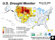

Drought Outlook
U.S. Drought Outlook. Graphic by the National Drought Mitigation Center.
|
|
Spring Drought Outlook
Small improvements noted for Wyoming
April 3, 2005
The latest Seasonal Drought Outlook indicates drought is likely to continue across the Northwest and northern Rockies into June, with only some temporary improvement for parts of the region.
Southwestern Wyoming and southeastern Idaho saw a one-category improvement in their drought ratings, according to the National Drought Mitigation Center in Lincoln, Nebraska. Additional heavy-mountain snows further reduced drought in Utah. Another 21 inches of snow at Alta on March 29 brought the season total to 575 inches at the ski resort, where snow depth reached 185 inches. Drought levels generally improved by one category in northern Utah, resulting in the removal of long-term dryness from central Utah into the Wasatch Mountains.
A shift in the weather pattern during the last half of March brought a more favorable storm track toward the region, suggesting that limited improvement is on tap, especially from the Cascades to the coast. However, it is unlikely that significant drought improvement can develop for most of the region this late in the wet season, given the near-record low mountain snowpacks.
Across the northern High Plains, some drought improvement is anticipated by late spring, although low winter snowpack ensures that the reservoir levels in the Missouri Basin is seen as a concern by weather forecasters.
According to the National Weather Service Climate Prediction Center, drought has rapidly worsened across the Northwest from Washington and Oregon eastward to Montana, as mountain snowpacks have dropped to record or near-record lows across the region.
Although forecasts for the last half of March show a promising tendency for increased precipitation, especially in western parts of Washington and Oregon, it is very unlikely that the Northwest will see significant improvement in the hydrological drought picture this late in the wet season, given the difficulty of making up the deficits following four consecutive months of below-normal precipitation.
Spring-summer water supply outlooks made in early March would place this year's flows among the bottom one or two of the last 70 years in the Pacific Northwest. Storms have continued to ease drought across the Southwest and Great Basin, and the latest seasonal drought outlook calls for additional improvement for lingering drought areas.
Melt from the extraordinary mountain snowpack in this region will boost streamflows this spring, improving reservoir supplies. Although even the larger reservoirs will benefit from this past winter's prolific snows, one season will not be enough to bring full recovery to the largest reservoirs, such as Mead and Powell on the Colorado River.
In the northern High Plains, including the upper Missouri River basin, below-normal mountain snowpacks will mean that hydrological drought will be ongoing, although late winter storms and spring rains should offer limited improvement by benefiting soil moisture.
In the South, spotty dry areas resulting from below-normal rainfall since October are not expected to develop into large-scale drought. Dryness that has recently developed in Puerto Rico will likely grow somewhat worse in coming weeks. The onset of the normal seasonal rains that begin in April-May will have a significant impact on whether dry conditions intensify. Forecast models for April-June suggest the dryness will not persist.
Related Links:
US Drought Monitor
Seasonal Drought Outlook
|
