
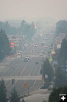
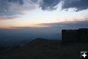
Pinedale Smoke
Smoke filled the air in Pinedale on the evening of Tuesday, August 15th. It also extended across the valley to Daniel, Boulder and down to Big Piney and Marbleton by dark.
|
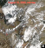
Mid-Afternoon Satellite Image
By mid-afternoon, winds had shifted to the northeast taking Nevada and Idaho smoke to the north of the Upper Green River Valley, where it appears to have been caught in downdraft winds from a thunderstorm over Togwotee Pass.
|
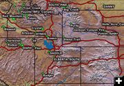
August fires
Fires burning in the region. Map by the US Forest Service Remote Sensing Applications Center, Salt Lake City.
|
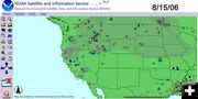
Smoke Drift on Tuesday
Smoke drift from fires on Tuesday, August 15. Map by NOAA Satellite and Information Services.
|
Trappers Point near Daniel
View from Trappers Point, looking west towards Daniel and the Wyoming Range. Trappers Point is a high ridge located just south of the Cora Highway turn-off, between Pinedale and Daniel, Wyoming on the south side of US Hwy 191. View shows smoke hanging low in the valley, with clear skies above.
|
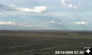
Daniel DEQ Cam 730pm
View from the Daniel DEQ air quality webcam at 7:30 PM on Tuesday, August 15. This webcam is located south of Daniel on the west side of Hwy 189. It is pointed east, looking towards the Wind River Mountains across the sagebrush hills of the Mesa.
|
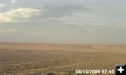
Daniel DEQ Webcam
View from the Daniel area DEQ Air Quality web cam showing what was happening at 7:45 pm on Tuesday.
|
|
Smoke: Idaho, Utah or Nevada?
by Dawn Ballou, Editor, Pinedale Online!
August 17, 2006
Update Friday, August 18: We finally received satellite imagery that gives a good picture of what happened on Tuesday. Smoke from fires in northeast Nevada and southeast Idaho was moving north of our valley most of the day. A large thunderstorm developed over Togwotee Pass in the evening, which could have produced strong downdraft winds that hit the northeast flowing smoke plumes and sent them crashing into our valley. The night-time cold air inversion kept the smoke trapped in the valley until winds cleared it out on Wednesday. See the MODIS fire detection satellite images, and the smoke drift graphic, at right.
---------------------------------
Tuesday’s smoke event was so unusual, we are continuing to investigate the incident to try and pin down the source of the smoke.
The official explanation from local U.S. Forest Service officials is, "Heavy smoke was visible throughout the area on Tuesday night. Lightning had sparked multiple large fires in eastern Idaho causing smoke to drift west into our area."
After discussions with the National Weather Service on wind patterns, listening to eye witnesses accounts, analysis of time-stamped webcam photos of when smoke arrived in certain areas around the valley, and discussions with people who live in Afton and Alpine, we have found more information to add to the story for those who are still trying to figure out exactly what happened on Tuesday and are unconvinced of the eastern Idaho wildfire smoke explanation.
The National Weather Service out of Riverton reported that the winds we were getting that day were predominently out of the southwest. They also reported that there was a large thunderstorm to the north of us near Togwotee Pass Tuesday evening.
Large fires were burning in southeast and middle Idaho, northern Nevada and south of the Great Salt Lake in Utah.
Satellite and infared imagery shows smoke trails from the Nevada fires heading our direction with the southwest flows on Tuesday. However, this smoke trail had not reached Pocatello, Idaho by 7:30 pm, so it is unlikely smoke from those fires were responsible for our smoke incident.
Smoke from the Utah fires south of the Great Salt Lake were directly in the path to be brought up by the southwest winds during the course of the day on Tuesday. Smoke from the Idaho fires would have gone to the north of us, based on Tuesday's wind patterns.
Discussions with residents in Alpine and Afton, Wyoming, (between us and the Utah smoke), also provided valuable insight. A person from Alpine said they did not notice any smoke on Tuesday evening, while another from Afton said it was “like LA smog” because the smoke was so thick. Afton is south of Alpine. Our webcams pointed at the Wyoming Range towards Triple Peak and Mount McDougal did not pick up any visible smoke coming over the Wyoming Range during daylight hours on Tuesday. The Bondurant webcam also did not show visible smoke during daylight hours Tuesday.
Daniel firefighter, Greg Anderson, described personally observing a high-altitude narrow trail of smoke that came over the Wyoming Range between Horse Creek and the Gros Ventre mountains. The observed the smoke trail travel across the valley and cross over the northern end of the Wind River Mountains. He said it was a long, thin “horsetail” smoke trail carried aloft at a high altitude. This observation also confirms the southwest to northeast directional flow of the wind pattern across the Upper Green River Valley that afternoon.
It is highly possible that the smoke trail was caught in the downdraft winds from the large thunderstorm occurring near Togwotee Pass to the north of us. This fits the visual observation that the smoke trail suddenly changed directions and came crashing to the valley floor where it was completely dispersed in a southwesterly direction down the western slope of the Wind River Range and into the Upper Green River Valley towards Pinedale. The thunderstorm downdraft winds also would account for the swirling winds going in multiple directions that were described occuring Tuesday evening around Pinedale and Daniel.
When the thunderstorm passed, the evening calm winds and colder air inversion kept the smoke in the valley overnight until morning winds from the southwest cleared it out on Wednesday.
So, for what it is worth, our conclusion now is that the smoke didn’t come from fires in eastern Idaho, but rather up from several large fires burning south of the Great Salt Lake in Utah. Smoke was carried aloft by the southwest winds, then diverted by the downdraft winds caused by the large thunderstorm that was over Togwotee Pass at that time. This filled the Upper Green with smoke from the Utah wildfires, and possibly some from the 7,900-acre Purdy fire, which is also burning to the west of Union Pass. Since the Jim Creek fire was putting up very little smoke all day on Tuesday, that fire was not the source for the intense smoke we experienced.
If any of our readers has more information to contribute to the explanation for this smoke incident on Tuesday, we would be interested in hearing it. E-mail: support@pinedaleonline.com, or give us a call at 307-360-7689 or 307-276-5699.
|