DEIS examines three South Rim wells
Draft Environmental Impact Statement for Plains Exploration & Production Eagle Prospect wells
by Cat Urbigkit, Pinedale Online!
March 5, 2007
The U.S. Forest Service has released the draft environmental impact statement on Plains Exploration and Production Company’s proposal to drill three exploratory wells in the Wyoming Range, seven miles southeast of Bondurant. If approved, the wells would evaluate production potential within the Eagle Prospect of the Bridger-Teton National Forest.
PROPOSED ACTION
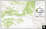
Under the proposed action, all three wells would be drilled from a single 4.5-acre well site. Access to the site would be through Merna along existing roads on National Forest land administered by the Forest Service, which would be reconstructed and realigned (including the Merna North Beaver Road). In addition, about 1,000 feet of new road will need to be constructed to access the well site.
PXP proposes the constructing, drilling, completing, testing, operating, and maintaining one to three exploratory wells and associated facilities, including an access road, staging area, two truck turnaround areas, a temporary pipeline, and production facilities.
Construction Activities
Construction activities are anticipated to occur over a 60-day period, considering 12-hour work days for most activities and, potentially, 24-hour operations for some activities such as hauling rock for road and well pad surfacing. The drilling of one to three wells would be accomplished in one to three drilling seasons, with the drilling rig removed from the location when idle during the winter months.
ENVIRONMENTAL IMPACTS
According to the DEIS, the primary effects associated with the proposal are fugitive (airborne) dust from construction activities and emissions from the proposed natural gas exploration activities. Noise from construction and drilling activity also would be associated with the proposed project.
Water & Stream Impacts
The proposed project may affect overall stream health and watershed conditions as well as groundwater quality and quantity during construction and operation phase, according to the DEIS. The effects on stream health and watershed conditions would be primarily tied to construction phase and would include potential increases in sedimentation to streams, potential effects on stream bank stability, and disruption of streambeds and aquatic habitat. Impacts to surface water could also result from maintenance-related surface disturbance.
Life of Project
For the life of a productive well (up to 30 years), there would be no new habitat disturbance following the construction phase, but continued human activity in the project area may displace wildlife from the project or alter their use patterns, according to the DEIS.
Routine maintenance
Routine maintenance of the facilities would be necessary to maximize their performance and safety and to maintain winter access, according to the DEIS. Telemetry systems would be installed to allow for remote monitoring of production and operational parameters of the facilities.
Wildlife impacts
Wildlife species may respond to the presence and noise of people, equipment, and machinery by avoiding areas of activity. The most noticeable increase in activities would occur during construction, when the drilling rig is mobilized, or when produced liquids are removed from the well pad during winter. If any of the wells is productive, the access road would be plowed, as needed, to allow for the removal of produced liquids from the well pad. Each time the road on NFS lands is opened up, an estimated two- to three-week period of intense snow plowing and hauling would occur.
Water for project
Water needed for the project would most likely be obtained from a combination of groundwater and surface water sources within watersheds of the Hoback River and the Upper Green River, according to the DEIS. A well would be drilled on location but may not have adequate flow to supply all project needs.
An additional well drilled near the access road may be used to supply water for dust abatement and road construction activities before the well pad is constructed. Additionally, water may be purchased from a nearby water rights holder and trucked to the project area. A surface water diversion may also be used to supply a portion of project water needs near construction activities.
PUBLIC INVOLVEMENT
The evaluation of the Eagle Prospect is anticipated to take up to five years. After evaluation, if any Eagle Prospect well is productive, full field development or long-term production of the Eagle Prospect wells would be considered in another environmental analysis document.
The Forest Service is accepting public comment through April 23. For more information, read the DEIS at www.fs.fed.us/r4/btnf/projects/. Review copies are available at the public libraries in Big Piney and Pinedale.
|