
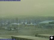
Snowing in Pinedale
This was the view from the Pinedale webcam around 6:00 PM on Wednesday, May 21, showing a snowstorm. We went from 80 degrees last weekend, to lightning and 70 miles an hour winds on Tuesday, to a return of chilly wintery weather on Wednesday. The outlook for Memorial Day weekend is cold and blustery. Plan for mixed weather for your holiday weekend activities (cloudy, rain, thunderstorms, wind, 50-60 degrees).
|

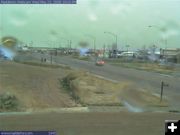
Snow Squall
Spring snow squalls can bring heavy wet snow. These storms typically blow through fairly quickly. View from the WYDOT Cora webcam Wednesday evening during the snowstorm.
|
Marbleton rain
Rain is a welcome sight for area ranchers wanting to get moisture in the ground for the grass to grow.
|
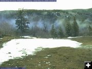
White Pine top view
View of snow level in the Wind River Mountains. The top of White Pine is approximately 9500 feet elevation.
|
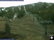
White Pine lodge view
The snow level is around 9,000 feet in the Wind River Mountains. The weekend storm is expected to bring more snow into the mountains. This is the view from the White Pine Ski Area lodge webcam on Wednesday evening.
|
|
Mixed bag of weather for next few days
Cold, thunderstorms, rain, snow, wind
by Pinedale Online!
May 21, 2008
The National Weather Service has a mixed bag of weather for Wyoming for the next couple of days. A strong cold front is moving across the state today (Wednesday, May 21) bringing much colder temperatures and a variety of weather in association.
Winter Storm Warning for eastern slopes of the Wind River Mountains
A Winter Storm Warning is posted for the east slopes of the Wind River Mountains from 6:00 PM through 6:00 PM Thursday. The Winter Storm Warning also applies to the Absaroka Mountains through Noon on Friday.
Snow Advisory for Yellowstone National Park
There is a Snow Advisory in effect for Yellowstone National Park through Noon on Friday.
Flood Warnings & Severe Thunderstorm Watches for east side of the state
The central and east side of the state have Flood Warnings and Severe Thunderstorm Watches in effect today to Thursday. The thunderstorms are expected to bring brief heavy rain and large hail, with strong wind gusts over 60 mph possible in association with the storms.
Rain to continue
Rain will continue over the north and west late this afternoon and evening.
Snow levels to decrease to 7000 feet Wednesday evening
Snow levels will decrease across central Wyoming to around 7000 feet Wednesday evening. This will allow upslope snowfall to develop over the eastern slopes of the Wind River Mountains and over the Absaroka Mountains. Snowfall will be heavy and wet Wednesday evening and will continue through the overnight hours.
South Pass & Togwotee Pass to get 12-15 inches of snow
Total snowfall of 12 to 15 inches is expected to impact South Pass and Togwotee Pass. This will make travel hazardous due to slick road conditions and limited visibilities. The National Weather Service is describing conditions as �snowpacked and treacherous� for these mountain passes. Motorists are advised to check current road conditions before traveling over these mountain passes Wednesday evening into Thursday. (Western Wyoming Road Report) These conditions are expected to diminish Thursday afternoon and evening.
Yellowstone Park to get 6-10 inches of snow
Yellowstone National Park is expected to get 6 to 10 inches of snow beginning Wednesday evening and overnight.
Lower elevations to get significant rainfall
Ranchers rejoice, the good news is that this system is expected to bring the potential for significant rainfall to lower elevations.
Memorial Day Weekend Forecast for Pinedale:
Mostly cloudy with a chance of showers and thunderstorms all three days. Temperatures in the 50-60s.
Weather Forecast:
Wednesday Night: Rain and snow likely, becoming all snow after midnight. Cloudy, with a low around 35. Breezy, with a north northwest wind 19 to 22 mph becoming west southwest 8 to 11 mph. Chance of precipitation is 70%. Total nighttime snow accumulation of 1 to 2 inches possible.
Thursday: Rain and snow likely, mainly after noon. Cloudy, with a high near 48. North northwest wind between 7 and 11 mph. Chance of precipitation is 70%. New snow accumulation of 2 to 4 inches possible.
Thursday Night: A 40 percent chance of snow showers. Cloudy, with a low around 31. South wind at 8 mph becoming west. New snow accumulation of around an inch possible.
Friday: A chance of showers, with thunderstorms also possible after noon. Mostly cloudy, with a high near 51. North wind around 5 mph becoming calm. Chance of precipitation is 40%.
Friday Night: A chance of showers and thunderstorms. Mostly cloudy, with a low around 36. South southeast wind between 6 and 9 mph. Chance of precipitation is 40%.
Saturday: A 40 percent chance of showers and thunderstorms. Mostly cloudy, with a high near 57.
Saturday Night: A chance of showers and thunderstorms. Mostly cloudy, with a low around 34. Chance of precipitation is 40%.
Sunday: A chance of showers. Mostly cloudy, with a high near 59.
Sunday Night: A slight chance of showers and thunderstorms. Mostly cloudy, with a low around 35.
Memorial Day: A slight chance of showers and thunderstorms. Mostly cloudy, with a high near 60. Monday Night: A chance of showers and thunderstorms. Mostly cloudy, with a low around 34.
Tuesday: A slight chance of showers. Mostly cloudy, with a high near 64.
Tuesday Night: A slight chance of showers and thunderstorms. Mostly cloudy, with a low around 37.
Wednesday: A slight chance of showers. Mostly cloudy, with a high near 68.
|