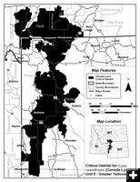
Sublette County lynx habitat
by U.S. Fish and Wildlife Service
February 25, 2009
The U.S. Fish and Wildlife Service announced a revised critical habitat designation for the Canada lynx, a species listed as threatened under the Endangered Species Act. In total, approximately 39,000 square miles fall within the boundaries of the revised critical habitat designation in the States of Maine, Minnesota, Montana, Wyoming, Idaho, and Washington.
Critical habitat is a term defined in the Endangered Species Act (ESA). It identifies geographic areas containing features essential for the conservation of a threatened or endangered species and may require special management considerations or protection.
Areas designated as critical habitat for the Canada lynx include boreal forest landscapes that provide one or more of the following beneficial habitat elements for the lynx including snowshoe hares for prey, abundant, large, woody debris piles that are used as dens, and winter snow conditions that are generally deep and fluffy for extended periods of time. All of the designated areas have recent verified records of lynx occurrence and reproduction and as a result are considered occupied.
In 2000, the Canada lynx was protected under the ESA as a threatened species throughout its range in the contiguous United States. In 2006, the Service designated 1,841 square miles of critical habitat for the lynx within the boundaries of Voyagers National Park in Minnesota, Glacier National Park in Montana, and North Cascades National Park in Washington. In February 2008, the Service proposed to revise the critical habitat designation after questions were raised about the integrity of the scientific information used and whether the decision made was consistent with appropriate legal standards.
Critical habitat is being designated based on the best scientific information identifying only those areas determined to contribute to the conservation of the Canada lynx. Areas included in the revised critical habitat designation include the following:
Maine: Approximately 9,497 square miles of habitat in portions of Aroostook, Franklin, Penobscot, Piscataquis, and Somerset Counties. Timber harvest and management is the dominant land use within this area.
Minnesota: Approximately 8,065 square miles of habitat in portions of Cook, Koochiching, Lake, and St. Louis Counties and Superior National Forest. Timber harvest and management is the dominant land use.
Northern Rocky Mountains - Northwestern Montana and a small portion of northeastern Idaho: Approximately 10,102 square miles in portions of Boundary County in Idaho; and Flathead, Glacier, Granite, Lake, Lewis and Clark, Lincoln, Missoula, Pondera, Powell and Teton Counties in Montana. The designation also includes National Forest lands and lands managed by the Bureau of Land Management in the Garnet Resource Area. Timber harvest and management is the dominant land use.
North Cascades - North-central Washington: Approximately 1,836 square miles in portions of Chelan and Okanogan Counties and lands managed by the Bureau of Land Management in the Spokane District. Timber harvest and management is the dominant land use.
Greater Yellowstone Area - Yellowstone National Park and surrounding lands in southwestern Montana and northwestern Wyoming: Approximately 9,500 square miles in portions of Gallatin, Park, Sweetgrass, Stillwater, and Carbon Counties in Montana; and Park, Teton, Fremont, Sublette, and Lincoln Counties in Wyoming. Impacts to lynx in this area include fire suppression or fuels treatment, the lack of an international conservation strategy for lynx, vehicular traffic, and residential and commercial development.
|
