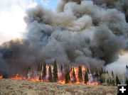

Maki Creek Burn
Flames engulf a stand of conifer and aspen trees on the Maki Creek prescribed fire in the Wyoming Range west of Daniel in the fall of 2008. Photo by Jill Miller, Wyoming Game & Fish Department.
|
|
Prescribed burn to begin in Maki Creek area
Smoke may be visible in the mountains west of Daniel
June 29, 2009
The Bridger-Teton National Forest plans to begin a prescribed burn in the Maki Creek-North Cottonwood area of the Wyoming Range on Monday, June 29. Residents of the Upper Green River Valley may see smoke from this fire.
Crews hope to ignite approximately 250-acres.
Maki Creek is located between North Cottonwood Creek and South Horse Creek on the Big Piney Ranger District.
The primary objective of the burn is to reduce fuel build up and restore aspen to the ecosystem. Some mechanical treatments were conducted previously using chainsaws to fall conifer trees that were encroaching on the aspen stands. Additional benefits of the prescribed burn will be to improve forage and help disperse elk off of nearby feedgrounds.
This fire is a cooperative project supported by additional funding from the Wyoming Game and Fish trust fund and the Wyoming Wildlife Natural Resource trust fund. Helicopters will be utilized to light the burn using aerial ignitions techniques. Ground crews with drip torches will also work to ignite the fire in the proper locations. Actual ignition will be dependent on meeting strict parameters for weather and fire behavior conditions.
Fire danger for wildfires is currently rated as Low on the Bridger-Teton National Forest.
Smoky conditions may exist in the immediate area and smoke may be visible from the towns of Pinedale, Daniel, and Big Piney. There are no road or trail closures associated with this project.
For more information on the fires please contact the Big Piney Ranger District at 307-276-3375.
|
