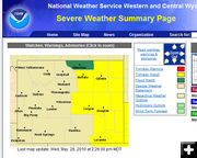
Tornado Watch for East-Central Wyoming Wednesday, May 26
May 26, 2010
A Tornado Watch is in effect for all of east and central Wyoming today, Wednesday, May 26, through 9 PM.
Widely scattered to scattered thunderstorms in Natrona and Johnson counties as well as the northeast Big Horn Basin and Big Horn mountains late Wednesday afternoon and early evening. A few storms across eastern Johnson county and northeast Natrona county could become severe with large hail and damaging wind. Stronger storms could produce isolated tornadoes.
Unseasonably warm temperatures are expected Thursday and Friday that will likely accelerate snowmelt in the eastern Wind River and eastern Big Horn mountains where snowpack remains well above average. Rivers and creeks in these areas will likely experience significant rises late this week.
A significant new storm system will move slowly into the Great Basin Thursday into Friday and across Wyoming Saturday and Sunday. This storm system will bring a high likelihood of precipitation with it as it moves slowly across western and central Wyoming. Showers and a few thunderstorms will move into the west as early as Thursday and then increase into Friday. Precipitation will become more widespread and then move east of the divide Friday into Saturday along with sharply colder temperatures. Much colder air will filter into northwest Wyoming where a cold valley rain and mountain snow is expected Friday through Saturday, including Yellowstone National Park. Showers will likely develop across much of central and north central Wyoming on Saturday and linger across north central Wyoming into Sunday. Stay tuned throughout the week for updates on this rapid transition from warm and dry to wet and colder once again for the Memorial Day weekend. Conditions however will likely improve considerably for Memorial Day.
National Weather Service spotters are encouraged to report any streams or rivers rising rapidly or near bankful.
|
