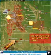
Red Flag Warning for high fire danger Aug. 26
August 26, 2010
The National Weather Service has issued a Red Flag Warning for portions of western and central Wyoming today. A hot and very dry unstable air mass will combine with very dry vegetation to produce a high fire danger Thursday afternoon and evening, especially across the western and northwestern mountains.
WESTERN AND CENTRAL WYOMING
A hot and very dry unstable air mass will combine with very dry vegetation to produce a high fire danger Thursday afternoon and evening, especially across the western and northwestern mountains.
FRIDAY THROUGH WEDNESDAY
A good chance of thunderstorms will occur Friday through Monday as an unsettled weather pattern takes shape over the western United States, with most of the activity taking place in western and northern Wyoming where thunderstorms are likely Saturday afternoon and evening. The greatest threat from the thunderstorms on Friday will be gusty winds. The main threat from thunderstorms on Saturday will be locally heavy rainfall, small hail and dangerous cloud to ground lightning.
Related Links:
Wyoming Weather Map National Weather Service
www.weather.gov National Weather Service
|
