Representatives
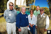
Representatives of the BLM and companies providing funding for the New Fork River Crossing Historical Park. (left to right). John Huston (BLM), Larry Elcock (Rocky Mountain Power), Aimee Davison (Shell), Chris Nelson (Rocky Mountain Power), Sam Drucker (BLM). Not pictured Cally McKee (Ultra). Photo courtesy Sublette County Historical Society.
|
Partners
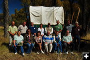
Representatives of the organizations involved in negotiation for funding of the New Fork River Crossing Historical Park. (Standing left to right) Jay Fear (SCHS), Dan Dockstader (LTF), Larry Elcock (RMP), Aimee Davison (Shell), Sam Drucker (BLM), Chris Nelson (RMP), John Huston (BLM), and Clint Gilchrist (SCHS). (Sitting left to right) Fern Linton (OCTA), Angie Thomas (SCHS), Laurie Hartwig (SCHS), Jermy Wight (LTF), Lesley Wischmann (AHW), and Tom Rea (AHW, OCTA). Not pictured Cally McKee (Ultra). Photo courtesy Sublette County Historical Society.
|
|
Agreements pave the way for historic New Fork River Crossing Park
by Joint media release
September 30, 2010
PINEDALE � A significant historical site on the Lander Wagon Road (commonly known as the Lander Trail) in the Pinedale Anticline area has been preserved thanks to agreements by the U.S. Bureau of Land Management (BLM), SWEPI LP (Shell), Ultra Resources (Ultra), and PacifiCorp (Rocky Mountain Power). As a result of the agreements, the three companies are funding the purchase of the property, to make it available to the public as the New Fork River Crossing Historical Park. Shell and Ultra are participating to mitigate natural gas field development impacts to the setting of the Lander Trail on the Pinedale Anticline. PacifiCorp is participating to mitigate transmission line impacts to the setting of the Lander Trail.
"Responsible development of natural gas on the Pinedale Anticline means respecting areas that are culturally and historically significant. Shell and Ultra�s contribution for the historical park will help preserve the setting and significance of the Lander Road, allowing future generations of residents and visitors to enjoy the history of Southwest Wyoming," said Aimee Davison, Natural Resources Advisor for Shell in Pinedale.
Larry Elcock, Rocky Mountain Power, Customer and Community Manager, said "We�re pleased to be part of this collaborative process to make the Lander Trail New Fork River Crossing Park a reality, and available to the public. Rocky Mountain Power has provided safe and reliable electric service to Wyoming customers for nearly 100 years, and we think it�s important to be a good corporate citizen and community partner in the areas we serve."
The Sublette County Historical Society (SCHS) will own, develop and operate the historical park in consultation with the BLM and other interested parties. Creation of the park provides a unique and permanent trail river setting experience for the public.
Other interested parties involved in the negotiations included the Advisory Council for Historic Preservation (ACHP), Wyoming State Historic Preservation Office (SHPO), Oregon-California Trails Association (OCTA), National Park Service � Long Distance Trail Office (NPS), Alliance for Historic Wyoming (AHW), Sublette County Historic Preservation Board (SCHPB), and the Lander Trail Foundation (LTF).
Once the park is developed, the Wyoming Land Trust will hold a permanent conservation easement on the property. Each of the three companies (Shell, Ultra and PacifiCorp) donated one-third of the cost of the property to SCHS, which affected the purchase of the property on August 20, 2010. SCHS will raise additional funds to develop the property.
Historical significance of the Lander Trail and New Fork River Crossing Historical Park site
The Lander Trail is part of the federally-designated National Historic Trails. Unlike other emigrant trails that evolved from repeated use, the Lander Trail was actually a constructed road, the first federally funded road west of the Mississippi River. The 256-mile wagon road, built in 1858, started at Burnt Ranch near South Pass, in Wyoming, and ended at Fort Hall in Idaho. It was an alternative to the original Oregon Trail through Fort Bridger, saving up to seven days of travel, avoiding larger desert sections and avoiding expensive ferry crossings over the Green River.
The road was engineered and built by its namesake, Frederick Lander. Lander had an extensive background in railroad construction in the east and had been part of the Pacific Railroad Survey in 1853. He worked on improving emigrant trails from 1857 until entering the Civil War in 1861. Lander died from a battle wound in 1862. He estimated that 13,000 emigrants used the new road in its first full year 1859. The road was used extensively until the transcontinental railroad was completed in 1869. The road continued to see some emigrant traffic into the 20th century and played an important role in the settlement of the area.
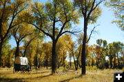
Major river crossings like the New Fork were significant markers for the emigrants because of the peril in crossing, but were also common camp spots. The New Fork River crossing was one of the most difficult on the Lander Trail, and because it followed an 18-mile waterless desert, the crossing was also a camp site for most emigrants. River corridors were later prized homestead sites, so almost all river crossings are now on private land.
The Lander Trail today
The Lander Trail has been marked and can be followed on public land for much of its length including the 18-mile desert section through the Green River Valley which is bisected by the Pinedale Anticline. The BLM and companies carefully manage the road through the Anticline with a no surface occupancy (NSO) for � mile on each side of the trail. Additionally a 3-mile viewshed buffer limits drilling activities, and best management practices minimize impacts to the road setting.
"The New Fork River Crossing land purchase marks a milestone in the achievement of adequate mitigation for impacts to cultural resources like the Lander Road due to the development of natural resources in the area," said David Welch, Oregon-California Trails Association, National Preservation Office.
Realistically, it is not possible to eliminate all impacts to the road setting. Instead of mitigating each separate impact to the road (i.e. a new well pad) as natural gas development progresses, these agreements recognize the overall effects over the life of the development and define an appropriate collective mitigation.
John Fowler, Executive Director of the Advisory Council on Historic Preservation said, "This was a good outcome for all parties, demonstrating how the Section 106 of the National Historic Preservation Act enables projects while protecting our heritage when creatively applied. The BLM mitigated adverse effects to the historic Lander Trail from both a new transmission line and additional gas and oil development. It permitted both efforts to proceed while protecting the historic river crossing by placing it in the hands of the Sublette County Historic Society."
Plans for the New Fork River Crossing Park
The New Fork River Crossing Historical Park sits about 5 miles west of the crest of the Anticline and just on the edge of the Pinedale Anticline Project Area (PAPA). The park is 82 acres in size with more than half a mile of river frontage. The setting at the park is very similar to what emigrants experienced 150 years ago. The goal is to leave the area as untouched as possible, so development of park facilities will be minimal. A parking lot will be developed at the entrance and the rest of the property will be accessible only by walking trails with interpretive signs. The park will be open in the summer for day use with no overnight camping. SCHS plans to open the park sometime during the summer of 2011.
"The New Fork River was an oasis after the desert to emigrants 150 years ago, half way along their 6-month journey to Oregon or California. During the peak summer months hundreds of people each day camped here before or after braving the dangerous crossing. After the emigrant era, the crossing was never cultivated, so remains today much like what the emigrants experienced. The gas development through the Pinedale Anticline could last a generation or two, but the New Fork Crossing Historical Park will now last forever. This is a tremendous legacy Shell, Ultra, PacifiCorp and the BLM have made possible," said Clint Gilchrist with the Sublette County Historical Society.
|