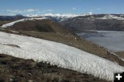

Atop Fremont Ridge
View from on top of the Fremont Ridge glacial moraine on Thursday, May 12. Roads to most trailheads are still either under snow or too soft to drive. Photo by Dave Bell.
|


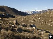
Below Fremont Ridge
Photo by Dave Bell. Conditions on May 12, 2011. Dave notes that the ticks are out "big time."
|
|
I want to go for a hike! Where can I go??
Trailheads are still inaccessible due to late snowmelt
by Dawn Ballou, Pinedale Online!
May 13, 2011
The late snowmelt has produced intense cabin fever in some who are aching to get outdoors and start hiking and exploring the backcountry. Most of the secondary roads are still either covered in snow or still closed because they are still too soft to drive on. All of the major trailheads are still inaccessible due to late spring snow, and the access roads are still closed. This includes the Upper Green, Elkhart Park and Big Sandy in the Wind River Range, and Horse Creek, the Cottonwoods and Greys River in the Wyoming Range. During our drought years, the high country passes of the Wind River Range have usually opened up by the 4th of July. This year the high country trails may not melt out until mid-to late July.
Current conditions can be observed by looking at the various webcams around the area:
Sublette County webcams: http://www.pinedaleonline.com/webcam/home.htm
Road and Weather conditions: http://www.pinedaleonline.com/roadconditions.htm
NRCS SNOTELS: http://www.wcc.nrcs.usda.gov/snotel/Wyoming/wyoming.html
The Pinedale and Big Piney Ranger Districts of the Bridger-Teton National Forest can provide additional information about conditions on the Forest. Open weekdays from 8AM to 4:30PM:
Pinedale Ranger District: 307-367-4326, 29 E Fremont Lake Road
Big Piney Ranger District: 307-276-3375, 10418 S. US Hwy 189
Bridger-Teton National Forest Supervisor’s Office (Jackson): 307-739-5500, 307-739-5010
Website: www.fs.usda.gov/btnf/
Email: r4_b-t_info@fs.fed.us
The Pinedale Field Office of the Bureau of Land Management can provide information about conditions on BLM land in Sublette County: 307-367-5300, 1625 W. Pine Street. Open weekdays from 7:45AM to 4:30PM.
We’ll post current conditions as we hear them. If anyone has been out exploring and can give us a condition report and/or current photo we can pass on, we’d appreciate your letting let us know. Please e-mail support@pinedaleonline.com or call/text 307-360-7689.
Click on this link for Dave Bell’s photos of his hike on Thursday, May 12th to Fremont Ridge along Fremont Lake. He accessed this by taking the road to the Fremont Lake outlet dam, 4 miles from Pinedale. He cautions that the ticks are out "big time." Fremont Ridge Hike May 12
|

