Winter Weather Advisory for Upper Green River Basin
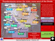
Falling temperatures, snow showers, thunderstorms
March 18, 2012
The National Weather Service in Riverton has issued a Winter Weather Advisory for the Upper Green River Basin and adjacent foothills which is in effect from 9 AM Sunday morning to 6 AM Monday. This advisory includes Pinedale, Big Piney, LaBarge, Farson, Kemmerer, and the western Wind River Mountains.
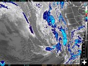
A strong cold front will push into the area from the west southwest ushering in increasing winds, sharply falling temperatures with rain showers changing to snow by 9 AM Sunday. Moderate to heavy snow showers with some embedded thunderstorms are expected late this morning through this afternoon and evening. Snowfall will linger after midnight Sunday night through 6 AM.
Snow accumulations 4 to 6 inches.
Southwest winds of 20 to 30 mph will produce some blowing and drifting snow reducing the visibility to below one-half mile at times by 8 pm Sunday evening. Any isolated thunderstorms could produce brief local wind gusts of 50 to 60 mph.
Travel on area highways including Highways 189 and 191 will become hazardous as slush on the highways freezes and becomes slick and snowpacked. Blowing snow will reduce the visibility after 8 pm Sunday night.
A Winter Weather Advisory means that periods of snow and blowing snow will cause travel difficulties. Be prepared for slippery roads and limited visibilities and use caution while driving.
The latest road conditions provided by the Wyoming Department of Transportation are available by calling 5-1-1 or on the internet at wyoroad.info.
Related Links:
www.weather.gov National Weather Service
Weather radar ional Oceanic and Atmospheric Administration (NOAA)
Wyoming Weather graphic National Weather Service
Travel, weather, webcam links Pinedale Online!
Area webcams Pinedale Online!
|

