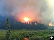
Fontenelle Fire at 37,041 acres
Evening update – June 29, 2012
by Fontenelle Fire management team
June 30, 2012
Status: The Fontenelle Fire is burning on the Bridger-Teton National Forest approximately 17 miles west of Big Piney, Wyoming. The fire began on June 24, 2012. As of 1800, the fire is currently 37,041 acres and burning in heavy, dead timber with occasional areas of grass and sage in the lower elevations.
Objectives for the Fire:
• Provide for firefighter and public safety
• Minimize impacts to oil/gas infrastructure & restore access as soon as safely possible
• Prepare and protect structures in Snider Basin
• Keep the fire to the east of Clear Creek
Recent Events: The fire progressed northeast and crossed Fish Creek today between Indian Creek and into BLM ground across the forest boundary. This afternoon the fire moved down Sawmill Canyon toward BLM and private land near Middle Piney Creek.
This afternoon large air tankers arrived on the fire and dropped fire retardant on the southeast edge. The fire retardant will allow hand crews to more safely construct fire line directly on the burn edge.
Additional personnel arrived on the incident bringing the 20-person crew total to seven.
Today’s Strategy: Firefighters were able to take advantage of slightly reduced winds and achieved containment along the southwest corner. Other containment lines were put in on various fronts, and as time passes, those areas will be improved and categorized as contained. Tonight a night shift will be established to protect structures along the Middle Piney road up to the Middle Piney summer homes.
The incident fire behavior analyst reported that the eastern edge of the fire has very little fire activity and shows very little potential growth toward Big Piney and Marbleton.
Forecast: A Red Flag warning expired at 9:00 pm this evening. No Red Flag warning is forecast for tomorrow; however winds and low relative humidity may prompt one for Sunday.
Closures: Road closures at present extend from the forest boundary at the top of Bare Pass at Red Castles, west to N. Piney Meadows and Tri Basin Divide, south to Cheese Pass, Mount Isabel, and Red Park, east to the junction of LaBarge Creek Road and the forest boundary, and north to Bare Pass. Further closures may be needed to ensure firefighter and public safety. The public is asked to be cautious when driving on the LaBarge Road between Hwy. 189 to the closure at the forest boundary as there may be large fire engines, fire traffic and impact from smoke.
More Information: Please visit www.fs.usda.gov/btnf, www.inciweb.org, or www.tetonfires.com, or follow us on Twitter at @WildeType2_IMT.
|
