
Fire July 4 - NASA satellite view
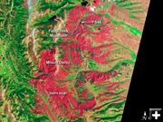
The Advanced Land Imager (ALI) on the Earth Observing-1 (EO-1) satellite acquired this image of the affected area on July 4, 2012, when the fire was 16 percent contained. Burned forests appear red in this false-color image; unburned forests are green. The blue patches along the brown ridges on Fish Creek mountain and the highlands to the west are snow.
|
|
Fontenelle Fire update – Saturday, July 7, 2012
59,346 acres, 45% contained, more public meetings scheduled, some cattle allowed to return to portions of fire area
by Great Basin IMT Team 5
July 7, 2012
Fontenelle Fact Sheet for Saturday, July 7, 2012, at 9:00 a.m.
Status: The Fontenelle Fire began on June 24, 2012 and is burning on the Bridger-Teton National Forest, BLM High Desert District, and state and private lands approximately 17 miles west of Big Piney, Wyoming. The fire is burning in heavy, dead timber with occasional areas of grass and sage in the lower elevations.
Fire Statistics: 59,346 acres burned or 92 square miles | 45% contained | 886 personnel on scene
Public Meetings: Local officials and fire managers will be sharing information about the fire and taking questions from the community at the following public meetings:
Saturday, July 7: Kemmerer 7 p.m., South Lincoln Training & Event Center, 215 Highway 233
Monday, July 9: Big Piney 7 p.m., LDS Church, 2266 Piney Road
Recent Events: Fire crews made significant progress on the north end of the fire with dozer line, water drops and burn outs. Efforts will be concentrated in this area to prevent the fire from moving farther north.
Continued cloud cover, high humidity, and low temperatures limited the fire’s growth to 2,022 acres on Friday. Less than 0.1’’ of rain fell on the fire overnight. Fire managers emphasize that recent rainfall was not significant enough to change the condition of dry fuels on the ground and that expected warmer weather and drier conditions could allow a resurgence of fire activity.
Some permittees will be allowed to move their cattle into portions of the fire area today. Fire managers will continue to work with permittees and industry representatives on a plan for re-entry into the fire area.
Today’s Strategy: Hotshot crews and dozers will again concentrate on the portion of the fire north of the Middle Piney Road. Firefighters will continue holding and building line on the east side of the fire’s perimeter. Mop-up operations will continue as crews extinguish remaining hot spots.
Forecast: Slightly increasing temperatures and lower humidity are predicted in the coming week with a possibility of thunderstorms and scattered showers.
Closures: Road closures continue to extend from the forest boundary at the top of Bare Pass at Red Castles, west to N. Piney Meadows and Tri Basin Divide, south to Cheese Pass, Mount Isabel, and Red Park, east to the junction of LaBarge Creek Road and the forest boundary, and north to Bare Pass. The road closure on Middle Piney Road may move east depending on fire conditions. Further closures may be needed to ensure firefighter and public safety. The public is asked to be cautious when driving on the LaBarge Road between HWY 189 to the closure at the forest boundary as there may be large fire engines, fire traffic and impact from smoke.
More Information:
www.fs.usda.gov/btnf
www.inciweb.org
www.tetonfires.com
Twitter: @WildeType2_IMT
Fontenelle Fire information phone: 307-276-3324
Related Links:
NASA Satellite imagery Fontenelle Fire July 6, 2012
Fire Restrictions
Expanded Closure Map
Fontenelle Fire photo gallery
|


