Lander Cutoff Road of the Oregon Trail
by Dawn Ballou
April 10, 2005
The Lander Cutoff Trail was a shortcut for those traveling the Oregon Trail to the Pacific Northwest. It is the only wagon road of the Oregon Trail system to ever be subsidized and constructed by the federal government.
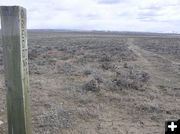
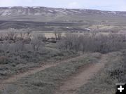
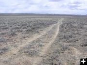
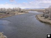
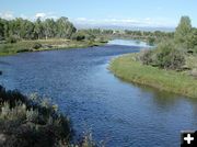
The trail transects the dry desert country of the Upper Green River Valley near Big Piney, crossing the New Fork and Green Rivers before heading into the Wyoming mountain range and on to Idaho. It was surveyed and built in 1857-58 by pioneer engineer Frederick Lander for the Department of the Interior as an improved emigrant wagon road.
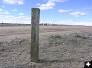
Some 13,000 emigrants traveled this route over to Fort Hall, Idaho and on to Oregon country. The route provided access to more water, wood and forage for stock animals than the Sublette Cutoff to the south. Many portions can still be driven today with a high-clearance vehicle, traveled by mountain bike or walked. Wooden posts mark the trail.
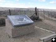
These photos were taken Sunday afternoon, April 10th. This site is located on the Boulder South Road, on the east side of the New Fork River, about one mile north of Highway 351. In addition to the trail and the wooden Lander Trail post marker, there is a historical sign at the site describing the nearby New Fork River crossing location as a stopping off point for travelers using the trail to rest.
The sign in part reads, "The Lander Road or �Trail� crosses the New Fork River just beyond this sign. Here, the river was shallow enough to allow emigrant wagons to ford the river without the aid of a ferry. The good water, livestock food and firewood made this a popular �layover� site� The Lander road first served in emigration, and later became the main link between ranches in the Green River Valley and people living in Star Valley to the west and Lander Valley to the east. Variously called the first fork of the Green River or the East River by early emigrants, the New Fork River was the first major river crossed in the Green River Basin."
For those who enjoy history, and don't mind the challenge of exploring on their own to find somewhat remote historic sites, this location offers a wonderful glimpse back into the past. The surrounding terrain hasn't changed too much and it is easy to imagine the days when early emigrants used the trail.
(Note, the nearest services are about 15 miles from here. Anyone exploring the actual trail should come prepared with a high-clearance vehicle, water/food, full tank of gas and a spare tire. The trail in these sections is rough, slow driving, remote and for those who don't mind taking their time reliving a bit of history at a slow pace. Free maps of the Lander Trail are available from the Bureau of Land Management office in Pinedale.)
Photos by Dawn Ballou, Pinedale Online
|