
Yellowstone earthquakees
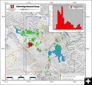
Map of Yellowstone National Park showing recent swarm earthquakes in red, previous swarms from 1995-2009 in green, and volcanic vents with yellow stars. Caldera boundaries are shown in orange. Mallard Lake Resurgent dome, to the southwest, and Sourcreek Resurgent dome, to the northeast, are shown with yellow lines. The histogram at the top right shows the number of earthquakes per day from January 15 to February 5. Image by Jamie Farrell and Robert B. Smith (University of Utah), data from the University of Utah Seismograph Stations.
|
|
Update on Yellowstone earthquakes
Update as of February 6, 2010
by Yellowstone Volcano Observatory
February 6, 2010
The current swarm at Yellowstone National Park has slowed considerably. Yellowstone Volcano Observatory (VCO) scientists continue to analyze the earthquakes and official updates to the earthquake count will resume on February 8th.
There were 7 earthquakes recorded by the University of Utah Seismograph Station (UUSS) automatic earthquake system on Friday, February 5th. All were beneath magnitude 2.0. As of February 5, 2010 9:00 AM MST there have been 1,771 earthquakes located.
The swarm began January 17, 2010 around 1:00 PM MST about 10 miles northwest of the Old Faithful area on the northwestern edge of the Yellowstone Caldera. Swarms have occurred in this area several times over the past two decades. This swarm has been longer (in time) and with more earthquakes than last year's swarm beneath Yellowstone Lake (December '08/January '09). The total seismic energy released is still somewhat less. The largest recorded swarm at Yellowstone remains the Fall 1985 swarm, which was located in a similar location, in the NW corner of the Yellowstone Caldera.
The current swarm has included 14 events with a magnitude larger than 3, 136 events of magnitude 2.0 to 2.9, 1,098 events with a magnitude of 1.0 to 1.9, and 530 events of magnitude 0.0 to 0.9. The largest events so far have been a pair of earthquakes of magnitude 3.7 and 3.8 that occurred after 11 PM MST on January 20, 2010. Both events were felt throughout the park and in surrounding communities in Wyoming, Montana, and Idaho.
See the University of Utah Seismograph Stations for the most recent earthquake data. Analysts are now working through all the automatic earthquake locations, and are refining hypocenter locations, depths and magnitudes for inclusion in the earthquake catalog. As the events are refined, they are listed on the UUSS website and loaded into the ANSS catalog . Seismograph recordings are also available online by clicking on the station of interest on the Yellowstone seismograph network station map.
Seismologists continue to review the earthquakes
Earthquakes with magnitudes greater than 2.5 are automatically located and then automatically plotted on the University of Utah Map of Recent Earthquakes. The smaller events must be analyzed by a seismic analyst to determine what are correct earthquakes from that area. Because the smaller events need to be individually located, they are added to the map later than those that are automatically located.
The delay in reporting the smaller earthquakes is usually not very noticeable, except when there are large numbers of very small earthquakes. There are currently seven members of the University of Utah Seismic Stations group who are working 24/7 to analyze the earthquakes. The smaller earthquakes can be viewed on the University of Utah Yellowstone seismic network helicorders. Please keep in mind that all of the earthquakes will be analyzed, but it will take time to get to the smaller ones.
Many of the larger (> M 2.5) earthquakes have been felt in the Park and in the surrounding area. If you feel earthquakes during the swarm, please fill out a form on the USGS "Did You Feel It?" web site: http://earthquake.usgs.gov/eqcenter/dyfi/. Information collected from the form is used for scientific research. Maps are generated by the form information for each felt earthquake. For more information about what others have felt, see the shake map created by responses after the largest earthquake in the current swarm,a M3.8 on Wednesday, January 20, 2010 at 23:16.
Monitoring the Yellowstone Volcano
YVO staff from the USGS, University of Utah, and Yellowstone National Park continue to carefully review all data streams that are recorded in real-time. At this time, there is no reason to believe that magma has risen to a shallow level within the crust or that a volcanic eruption is likely. The current swarm earthquakes are likely the result of slip on pre-existing faults rather than underground movement of magma. The USGS Volcano Alert Level and Aviation Color Code for Yellowstone remains at Normal and Green.
At this time, no one has noted any anomalous changes in surface discharges (hot springs, gas output, etc.). Keep in mind that it is winter and much of the park is covered in snow. The Old Faithful webcam provides views of that area along with weather information.
The Yellowstone Volcano Observatory (YVO) is a partnership of the U.S. Geological Survey (USGS), Yellowstone National Park, and University of Utah to strengthen the long-term monitoring of volcanic and earthquake unrest in the Yellowstone National Park region. Yellowstone is the site of the largest and most diverse collection of natural thermal features in the world and the first National Park. YVO is one of the five USGS Volcano Observatories that monitor volcanoes within the United States for science and public safety.
Swarms are common at Yellowstone
The current number of earthquakes per day is well above average at Yellowstone. Nevertheless, swarms are common at Yellowstone, with 100s to 1000s of events, some of which can reach magnitudes greater than 4.0. For example, during the December 2008 - January 2009 Yellowstone Lake swarm, there were about 900 earthquakes. The largest earthquake was a magnitude 3.9. The 1985 swarm, also on the northwest rim of the caldera but several miles from the current swarm, lasted for three months. During the 1985 swarm there were over 3000 total events recorded, with magnitudes ranging up to M4.9.
Daily summaries are available at:
http://volcanoes.usgs.gov/yvo/publications/2010/10swarm.php
|