
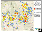
Sage Grouse Map
Greater Sage Grouse Range-Wide Breeding Density Thresholds. Map by Bureau of Land Management, Department of the Interior.
|
|
Sage-Grouse Habitat Map in the West available
by Bureau of Land Management
November 23, 2010
WASHINGTON, D.C. – Secretary of the Interior Ken Salazar today (Tuesday, November 23, 2010) announced the completion of a breeding bird density map for the greater sage-grouse by the Bureau of Land Management in coordination with the Western Association of Fish and Wildlife Agencies, the U.S. Fish and Wildlife Service, and the Natural Resources Conservation Service.
The map identifies important range-wide focal areas having high density occurrences of greater sage-grouse, a ground-dwelling bird that inhabits much of the West. These focal areas were determined by estimating the male’s attendance on leks, the communal breeding grounds of the bird. The BLM will work with the state fish and wildlife agencies to further refine the map by incorporating more specific state-level data.
"This map and initiative will help advance our collaborative efforts with states and stakeholders to develop smart policy to enhance the sustainability of our sage-grouse populations," Salazar said. "The final map will give Interior a strong foundation to identify land uses that do not compromise areas that are so critical to the greater sage-grouse."
"As the federal land manager of more sage-grouse habitat than any other entity, the BLM takes very seriously our commitment to working with others to manage America’s natural resources," said BLM Director Bob Abbey. "This mapping effort will help other federal and state agencies and the BLM as it carries out its multiple-use mandate. We are confident that all activities can be managed to be compatible with conservation of the sage-grouse and its habitat."
Abbey provided an overview of the mapping effort last March, when Secretary Salazar announced the Fish and Wildlife Service’s finding that the greater sage-grouse warranted protection under the Endangered Species Act, but that listing the species at this time is precluded by the need to address higher priority species first.
The Fish and Wildlife Service provided technical expertise in the development of the map. The NRCS will utilize the map in implementing their Sage-Grouse Initiative. WAFWA agencies are also ready to begin using the valuable management tool.
"We are pleased with this collaborative, state/federal effort, and look forward to continuing the important work of conserving this iconic species of the American West," said Ken Mayer, Director of the Nevada Department of Wildlife and the WAFWA lead for sage-grouse conservation.
"USDA is honored to collaborate with state and federal partners in targeting NRCS's new Sage-Grouse Initiative to deliver the right conservation practices in the right places," said NRCS Chief Dave White. "New breeding density maps are critical to SGI's targeted approach to ensure the largest biological return on our conservation investment."
"The greater sage-grouse has historically inhabited millions of acres in the West, making it imperative that we work across political and administrative boundaries at a landscape scale to protect and restore sagebrush habitat," said Acting Service Director Rowan Gould. "This map provides vital information that will enable us to work together to prevent further habitat fragmentation and undertake other conservation work to ensure the species’ long term survival."
Greater sage-grouse are found in Washington, Oregon, Idaho, Montana, North Dakota, eastern California, Nevada, Utah, western Colorado, South Dakota and Wyoming and the Canadian provinces of Alberta and Saskatchewan. They currently occupy approximately 56 percent of their historical range.
View the sage-grouse breeding bird density map at http://blm.gov/kb5c.
|